

Modernizing Municipal Infrastructure with End-to-End GIS Managed Services
About the client
The customer is a large municipal government in North America, responsible for managing one of the continent's most complex urban infrastructures. With a resident population exceeding 3 million, the city operates across a vast and densely interconnected network of systems from arterial road corridors and aging bridge structures to underground water mains, stormwater drainage networks, and a broad portfolio of public facilities including parks, civic centers, and transit hubs.
City planning and infrastructure management at this scale demands continuous, coordinated decision-making across dozens of departments. Teams responsible for transportation, utilities, emergency services, environmental management, and land use planning must work in sync often responding to competing priorities and tight operational timelines. The volume, velocity, and variety of spatial data generated across these functions is enormous, and growing year over year.
To manage this complexity, the city had long relied on Geographic Information Systems as a foundational technology layer. GIS served as the backbone for asset tracking, spatial analysis, infrastructure inspection workflows, permit management, and capital planning. Department heads, field engineers, urban planners, and policy teams all depended on geospatial data to do their jobs effectively whether routing maintenance crews, modeling flood risk, assessing road wear, or planning new development corridors.
However, over time the city's GIS environment had grown organically and without a unified strategy. Individual departments had built or procured their own GIS tools and datasets, resulting in a fragmented technology landscape. Platforms varied in version, vendor, and configuration. Data schemas differed between teams. Workflows that should have been seamless required manual reconciliation. What had begun as a functional set of tools had evolved into a technical liability.
As data volumes continued to climb driven by expanding IoT sensor networks, satellite imagery feeds, drone surveys, and real-time operational data, the strain on the city's GIS infrastructure became increasingly apparent. System performance degraded under heavy query loads. Scheduled updates fell behind. Downtime, while infrequent, had measurable impact on field operations and planning workflows that depended on live geospatial access.
Internally, the city's IT teams were capable generalists but lacked the depth of specialized GIS expertise needed to manage, optimize, and evolve enterprise-grade geospatial platforms. Keeping pace with platform upgrades, data pipeline maintenance, and integration requirements demanded skills and bandwidth that simply were not available in-house. As a result, the city began to seriously evaluate GIS managed services as a strategic path forward, one that would allow it to modernize its geospatial infrastructure, improve system reliability, and free internal teams to focus on core administrative priorities rather than platform upkeep.
Challenges
The city's existing GIS environment consisted of multiple legacy systems that were difficult to maintain and scale. System performance issues and occasional downtime impacted the ability of city departments to access critical geospatial data. Internal IT teams lacked the specialized expertise required to manage advanced GIS platforms, leading to delays in system updates and enhancements.
Data inconsistencies across departments also created challenges in infrastructure planning and decision-making. Additionally, the city needed to integrate new data sources such as real-time traffic data, IoT sensor data, and environmental monitoring systems into its GIS platform. Without a dedicated GIS management strategy, the administration struggled to keep up with evolving technology requirements.
Solution
- Implemented a comprehensive GIS managed services model with ongoing system management, monitoring, and optimization.
- Established a centralized GIS management framework to standardize data across departments and ensure geospatial dataset consistency.
- Deployed cloud-based GIS infrastructure to improve system scalability and performance.
- Supported integration of new data sources, including real-time traffic data and IoT-enabled infrastructure systems.
- Implemented regular system updates, performance tuning, and data governance practices for long-term sustainability.
- Maintained and enhanced interactive dashboards and geospatial analytics tools to support urban planning and decision-making.
Key ROI & business benefits
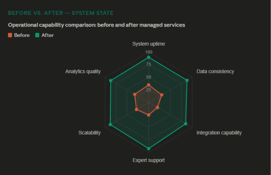
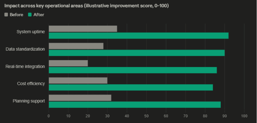
- System uptime & performance across all departments
- Unified data standards enabling cross-agency collaboration
- Real-time data powering traffic, utility & service management
- Reduced costs by eliminating in-house GIS support overhead
By leveraging GIS managed services for municipal infrastructure, the city established a modern, scalable, and data-driven approach to urban management.
Conclusion
By leveraging GIS managed services for municipal infrastructure, the city established a modern, scalable, and data-driven approach to urban management. The transition from fragmented legacy systems to a unified, cloud-based GIS environment marks a pivotal step in the city's digital transformation journey, one that directly strengthens its ability to serve over 3 million residents with greater efficiency, transparency, and responsiveness.
As urban infrastructure continues to grow in complexity, this managed services model positions the city to adapt confidently integrating emerging technologies, maintaining data integrity across agencies, and making smarter, faster decisions that shape the future of the city for generations to come.